Top 10 Highest Mountains in Kenya (2026) – Peaks, Hiking Routes & Photos
- BeyondForest

- Dec 6, 2024
- 10 min read
Updated: Mar 13

By the end of this section you will have learnt
0.)About Mountains in Kenya
1.)FAQ about Mountains in Kenya
Kenya is home to some of the most iconic mountains in Africa, offering breathtaking landscapes, rich biodiversity, and cultural significance. These mountains are not only landmarks of the country but also play a critical role in its climate regulation, water supply, and tourism.

Image of Mount Longonot
Below is a List of Mountains in Kenya and their counties
Mount Kenya | Nyeri County,Meru County | 5,199 meters |
Mount Elgon | Bungoma County | 4,321 meters |
Mount Satima | Nyandarua County. | 4,001 meters |
Mount Longonot | Nakuru County | 2,776 meters |
Mount Suswa | Narok County | 2,356 meters |
Mount Kipipiri | Nyandarua County | 3,370 meters |
Mount Mtelo | West Pokot County | 3,336 meters |
Mount Ng'iro | Samburu County | 2,850 meters |
Mount Poi | Samburu County | 2,500 meters |
Mount Kasigau | Taita-Taveta County | 1,640 meters |
Table Mountain | Nyandarua County | 3,870 meters |
Mount Kinangop | Nyandarua County | 3,906 meters |
Mount Ololokwe | Samburu County | 2,779 meters |
Mount Kulal | Marsabit County | 2,377 meters |

Whether it’s Mt. Kenya, Aberdares, Mt. Elgon, or Mt. Satima, we help connect you with:
Certified local mountain guides
Affordable hiking & climbing packages
Porters, camping gear & logistics
Custom itineraries for solo travelers, groups & photographers
Tell us 👉 Here >>>
Safest Summit is Point Lenana (4,985m) as it requires no technical skills.
Mount Kenya, Africa’s second-highest peak at 5,199m (17,057 ft.), is a UNESCO World Heritage Site renowned for its dramatic glacial valleys, diverse ecosystems, and challenging climbs. This extinct volcano’s jagged peaks—Batian, Nelion, and Point Lenana—attract hikers, alpinists, and nature lovers.

The mountain transitions from lush rainforests (2,000m) to bamboo forests, alpine meadows, and finally rock/ice summits. Though shrinking due to climate change, Lewis, Tyndall, and Darwin glaciers remain visible.
Mount Elgon

Mount Elgon, an extinct shield volcano straddling the Kenya-Uganda border, is Africa’s oldest and largest volcanic mountain by base area (50km x 80km).

Its highest peak, Wagagai (4,321m), lies in Uganda, while Kenya’s Koitoboss (4,222m) offers dramatic cliffs and caves.Mount Elgon is Famous for its vast caldera (40km²), lava tubes, and hot springs near the summit.Kitum Cave attracts elephants that lick salt deposits (featured in Richard Preston’s The Hot Zone).Hiking Routes on Mount Elgon Kenyan Side include

Sasa Trail – Shortest but steepest (4 days, starts at 2,450m).
Piswa Trail – Gentle slope through pine forests (7 days, best for wildlife).
Chorlim Gate – Accesses Koitoboss Peak with panoramic views
Plan Your Kenya Mountain Adventure — Stress-Free
Visiting Kenya and planning to hike one of its iconic mountains?We help international travelers connect with trusted local guides, hiking companies, and support teams for:
Mount Kenya summit climbs
Scenic hikes in the Aberdares & Mount Elgon
Photography & nature-focused treks
Small groups, solo travelers & private trips
Tell us 👉 Here >>>
Mount Satima (4,001m), the tallest point in Kenya’s Aberdare Range, offers a rugged, less-trodden alternative to East Africa’s more famous peaks. This volcanic remnant is named after the Kikuyu word "Satimma" (young bull), reflecting its cultural significance.

Mount Satima is Known for its sheer cliffs, alpine moorlands, and panoramic views of the Rift Valley.Home to bongo antelopes, elephants, and rare birds like the Aberdare cisticola.Hiking Routes for Mount Satima include

Wandare Gate Approach – 2-day trek through bamboo forests and giant heather zones.
The Elephant Trail – Chance to spot wildlife (requires armed rangers).
Summit Circuit – Leads to the "Dragon’s Teeth" rock formations.
Mount Longonot is a stratovolcano located located in Nakuru County, in the Great Rift Valley, about 60 kilometers northwest of Nairobi, Kenya. It lies within Mount Longonot National Park, managed by the Kenya Wildlife Service. Mount Longonot stands at 2,776 meters (9,108 feet) above sea level. The mountain features a large, well-defined caldera that is approximately 8 kilometers in circumference. The crater floor is forested and a significant point of attraction for hikers

Image of Mount Longonot in Nakuru county
. Mount Longonot's name originates from the Maasai word Oloonong’ot, meaning "mountain of many spurs" or "steep ridges." Mount Longonot last erupted in the 1860s, and while it is currently dormant, its volcanic history has shaped the rugged terrain.
Mount Ololokwe is a prominent mountain located in northern Kenya, specifically in the Samburu County. It stands out as a significant landmark due to its unique, flat-topped appearance and its cultural importance to the local communities .,Mount Ololokwe is located in Samburu County the northern part of Kenya, about 45 kilometers (28 miles) northeast of the town of Nanyuki. Mount Ololokwe has an elevation of about 2,779 meters (9,118 feet) above sea level.

The mountain is notable for its mesa-like shape, with a wide, flat summit that contrasts with the jagged peaks of nearby mountains. It is a sacred site for the Samburu people, and local legends and customs are tied to the mountain. The area around Mount Ololokwe is rich in wildlife, including elephants, buffalo, and various bird species, making it an interesting location for nature enthusiasts.
Mount Kinangop

Mount Kinangop (3,906m), the second-highest peak in Kenya's Aberdare Range, offers adventurers a challenging yet rewarding climb.Named after the Kikuyu phrase "Ki-Nyangop" (place of ostriches), this isolated peak rises abruptly from the Kinangop Plateau, creating dramatic scenery.Mount Kinangop is Characterized by rolling tussock grasslands, rocky outcrops, and alpine vegetation at higher elevations.Mount Kinangop offers stunning views of the Rift Valley and authentic wilderness experiences. The summit provides panoramic vistas of Lake Naivasha and Longonot Volcano.
Looking for the Best Mountain Views in Kenya?
From sunrise above the clouds on Mt. Kenya to dramatic landscapes in the Aberdares and Elgon, we help you plan hikes that match your pace, goals, and photography interests.
Share your hiking goals and we’ll recommend the right mountain, route, and local guide.
Tell us 👉 Here >>>
Mount Kulal is an isolated volcanic mountain located in the northeastern part of Kenya. It is part of the larger Kulal Mountain Range, which is situated in the semi-arid region near the border of Kenya and Ethiopia .Mount Kulal is located in Marsabit County, in the northern part of Kenya. It's positioned to the northeast of Lake Turkana, approximately 100 kilometers (62 miles) south of the Ethiopian border. The mountain rises to an elevation of about 2,377 meters (7,799 feet) above sea level, making it a notable peak in the region. Mount Kulal is a relatively isolated peak compared to other large mountain ranges in Kenya. Its summit is a large volcanic caldera, and it is surrounded by a rugged and arid landscape.

The mountain is about 15 kilometers (9 miles) in diameter. Mount Kulal is a shield volcano, and its distinctive flat-topped shape is the result of volcanic activity over millions of years. Mount Kulal is considered sacred by local pastoral communities such as the Borana and Samburu people. They associate it with spiritual beliefs and traditional practices.
Mount Suswa is a fascinating shield volcano located located in Narok County in the Great Rift Valley, Kenya, situated between Narok and Nairobi counties. It stands at an elevation of 2,356 meters (7,730 feet) above sea level.

This mountain is distinctive for its twin-crater system, which features an inner crater approximately 5 kilometers wide, surrounded by a moat-like depression and a central island. The outer crater has a circumference of around 10 kilometers and hosts numerous Maasai settlements .The mountain is an extinct volcanic complex, and its base spans a considerable area. The crater and volcanic features cover about 50 square kilometers. The summit area consists of a relatively flat plateau with deep volcanic craters. Mount Suswa is part of the East African Rift, a geologically active area where tectonic forces have shaped the landscape. The mountain's features include lava flows, craters, and volcanic tunnels.
Mount Kasigau is located in Taita-Taveta County, in southeastern Kenya. Approximately 3.863°S latitude and 38.644°E longitude. Mount Kasigau is situated about 50 kilometers (31 miles) southeast of Voi town, along the route connecting the Tsavo West and Tsavo East National Parks. Close to the Kenya-Tanzania border and near the Kasigau Corridor, a critical wildlife migration route. Mount Kasigau rises to approximately 1,640 meters (5,380 feet) above sea level. Mount Kasigau is a volcanic inselberg (an isolated hill or mountain) that stands out distinctly from the surrounding plains.

Image of Mount Kasigau
The montane forest is rich in plant diversity, including indigenous tree species such as Podocarpus and Newtonia. A haven for numerous species, including elephants, leopards, baboons, and small mammals. The mountain supports rare and endemic species, such as the Kasigau Pygmy Chameleon (Kinyongia asheorum) The mountain holds cultural and spiritual significance for the Taita people, who associate it with traditional practices and beliefs
Table Mountain in the Aberdare Range is located in Nyandarua County, Kenya Table Mountain is approximately 0.183°S latitude and 36.700°E longitude. Located near the Aberdare National Park, a key conservation area in the region.Easily accessible from towns like Nyahururu and Nyeri.

Table Mountain in the Aberdares rises to an elevation of approximately 3,870 meters (12,697 feet) above sea level, making it one of the prominent peaks in the Aberdare Range. Named "Table Mountain" due to its relatively flat summit, resembling a tabletop.

Image of Table mountain
The mountain and its surrounding area are part of the Aberdare ecosystem, which spans approximately 2,000 square kilometers (772 square miles) as part of the larger Aberdare Conservation Area. The Aberdares, including Table Mountain, are a critical water tower for Kenya. They feed rivers like the Tana, Ewaso Nyiro,
Mount Kipipiri, located in Nyandarua County, Kenya, is a prominent peak near the Aberdare Range. Its elevation reaches approximately 3,370 meters (11,056 feet) above sea level, making it a notable landmark in the region. The mountain is positioned about 32 kilometers northeast of Lake Naivasha and is part of the Aberdare National Park, serving as a vital habitat for various wildlife, including elephants, buffalos, and different monkey species

The name "Kipipiri" translates to "butterfly" in the local Kikuyu language, inspired by the mountain's shape when viewed from a distance. It is surrounded by lush forests covering about 43 square kilometers, which are protected to conserve biodiversity and prevent human-wildlife conflicts

Image of Mount mtelo
Mount Mtelo is located in West Pokot County, Kenya. Approximately 1.75°N latitude and 35.25°E longitude. It lies near the town of Kapenguria, in the Cherangany Hills range, about 100 kilometers northeast of Kitale.
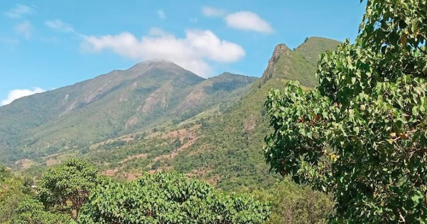
Image of Mount Mtelo at west pokot
Mount Mtelo stands at approximately 3,336 meters (10,944 feet) above sea level, making it one of the highest peaks in the Cherangany Hills and a prominent feature of the region. It is part of the Cherangany Hills, which is a critical ecological and water catchment area in Kenya. Mount Mtelo is revered by the Pokot community, who consider it a sacred site.
Mount Ng'iro
Mount Ng'iro also known as Mount Nyiru is situated in Samburu County, in northern Kenya. Approximately 1.19°N latitude and 36.85°E longitude. Located northeast of Maralal, the administrative center of Samburu County.

It is part of the larger northern Kenyan highlands, not far from the Samburu National Reserve and the surrounding arid plains. Mount Ng'iro stands at approximately 2,850 meters (9,350 feet) above sea level. Mount Nyiro is part of the Samburu Highlands, characterized by rugged terrain, steep slopes, and scenic ridges.
Mount Poi
Mount Poi is located in Samburu County, Kenya. Approximately 1.53°N latitude and 37.04°E longitude. It is situated within the Ndoto Mountains, a range in northern Kenya. Lies near the village of South Horr, which serves as a base for travelers visiting the mountain. Located roughly 50 kilometers (31 miles) south of Baragoi and near the scenic Lake Turkana region. Mount Poi rises to approximately 2,500 meters (8,202 feet) above sea level

Although it is not the tallest mountain in the region, it is a prominent peak due to its dramatic rock formations and steep cliffs. Mount Poi is renowned for its massive granite walls, making it a popular destination for rock climbers and adventurers. Mount Poi Offers incredible vistas of the Suguta Valley, Lake Turkana, and the broader Ndoto Mountain range.

1. Deforestation
Logging, charcoal burning, and land clearing for agriculture reduce forest cover which Impacts the Loss of biodiversity, soil erosion, and reduced water availability.
2. Climate Change
Rising temperatures are causing glacier retreat on Mount Kenya. Altered rainfall patterns affect ecosystems and water supplies.
3. Encroachment and Overgrazing
Expanding human settlements and livestock grazing degrade mountain ecosystems. For instance Aberdare and Cherangani Hills face significant pressure from overuse.
4. Poaching and Wildlife Conflicts
Illegal hunting threatens wildlife populations.Human-wildlife conflicts arise as communities encroach on wildlife habitats.
5. Invasive Species
Non-native plants and animals disrupt native ecosystems. For instance the spread of Lantana camara in the Aberdare Range.
FAQ about Mountains in Kenya
What Is The Difference Between a Hill and a Mountain
The primary difference between a mountain and a hill lies in their size, formation, and perception, but there is no universally agreed-upon distinction as definitions vary across cultures and geographic standards. Mountain are generally taller than 600 meters (about 2,000 feet) above sea level, though some definitions use 300 meters (about 1,000 feet) as a threshold. Hills are Shorter and often less steep than mountains, usually below the 300-600 meter threshold. Mountains Typically has a steeper incline and rugged terrain. While Hills Slopes are gentler and less pronounced. Mountains are Formed primarily through tectonic activity (e.g., folding, faulting, or volcanic activity).While Hills are often formed by erosion, accumulation of sediment, or smaller geological uplift.
Kenya has approximately 15 notable mountains, ranging from volcanic peaks to rugged highlands. Here’s a breakdown If you're counting only volcanic or named standalone mountains, the number is closer to 7–10, but if you include highland ranges and hills with significant elevation, it goes over 15.

The most famous mountain in Kenya is Mount Kenya, which is also the highest mountain in Kenya and the second-highest in Africa after Mount Kilimanjaro with an elevation of 5,199 meters (17,057 feet) above sea level
How many mountains are in Kenya
Kenya is home to dozens of mountains and highland ranges, shaped by volcanic and tectonic activity along the Great Rift Valley. While there’s no fixed number due to varying classifications of hills vs. mountains, Kenya has over 30 well-recognized mountains.
The tallest is Mount Kilimanjaro, located in Tanzania, stands at an impressive 5,895 meters (19,341 feet) above sea level, making it the tallest mountain in Africa. It is a freestanding volcanic mountain with three volcanic cones: Kibo (the highest), Mawenzi, and Shira. In comparison, Mount Kenya, located in central Kenya, is the second-highest mountain in Africa, with its highest peak, Batian, reaching 5,199 meters (17,057 feet) above sea level. It is an extinct stratovolcano and known for its jagged peaks, glaciers, and alpine vegetation.
Yes, Mount Kenya is generally considered harder to climb than Mount Kilimanjaro, especially for climbers aiming to summit its highest peaks.Mount Kenya is shorter but technically harder, while Kilimanjaro is taller but easier for beginners aiming for Africa’s highest point.


Trong một lần mình đánh giá tổng thể MB88, mình nhận thấy hệ thống vẫn duy trì được sự rõ ràng trong cách trình bày nội dung, casino live, game bài và bắn cá được đặt ở những khu vực riêng biệt nên việc theo dõi không bị chồng chéo, mình thấy giao diện có độ thoáng vừa phải giúp quan sát lâu vẫn khá dễ chịu, trong lúc trải nghiệm thì tốc độ phản hồi ổn định, thao tác chuyển đổi giữa các mục diễn ra nhanh nên cảm giác sử dụng tương đối liên tục
Khi trải nghiệm S8 mình thấy hệ thống này có sự cân bằng giữa thiết kế và hiệu năng. Giao diện được sắp xếp hợp lý giúp mình không mất thời gian tìm kiếm nội dung. Các chuyên mục như casino, thể thao, bắn cá và slot game được phân chia rõ ràng nên việc truy cập khá thuận tiện. Trong quá trình sử dụng, mình thấy tốc độ xử lý tương đối nhanh và ổn định ngay cả khi chuyển đổi liên tục. Điều mình đánh giá cao là trải nghiệm tổng thể không bị rối mắt, mang lại cảm giác dễ chịu khi sử dụng lâu dài và phù hợp để giải trí thường xuyên
Có thời điểm mình tìm hiểu cách nhiều nền tảng giải trí trực tuyến sắp xếp hệ thống nội dung và nhận thấy ko66 chú trọng khá nhiều đến trải nghiệm điều hướng. Các chuyên mục như casino trực tuyến, thể thao, đá gà, nổ hũ và bắn cá được bố trí thành từng khu vực riêng giúp việc tiếp cận thông tin diễn ra nhanh hơn. Mình thấy giao diện không bị nhồi nhét quá nhiều chi tiết nên việc quan sát khá nhẹ nhàng. Trong quá trình thử casino trực tuyến và đá gà, hệ thống phản hồi tương đối đều, tốc độ xử lý có vẻ ổn định và thao tác chuyển chuyên mục diễn ra liền mạch…
Điều tôi đánh giá cao khi trải nghiệm ko66 là khả năng tổ chức hệ thống theo từng nhóm nội dung thay vì hiển thị dàn trải trên cùng một màn hình. Các khu vực thể thao, casino live, game bài, nổ hũ, bắn cá, đá gà, xổ số và ưu đãi đều được bố trí trực quan để người dùng dễ theo dõi. Trong quá trình thao tác, giao diện phản hồi nhanh, tốc độ tải dữ liệu được duy trì khá ổn định và việc chuyển đổi giữa các chuyên mục diễn ra thuận lợi. Điều này giúp người dùng khám phá toàn bộ nền tảng dễ dàng hơn, đồng thời duy trì trải nghiệm liền mạch qua nhiều…
Trong quá trình mình quan sát cách s8 xây dựng trải nghiệm người dùng, mình nhận thấy nền tảng này tạo được sự cân bằng giữa số lượng nội dung và khả năng hiển thị. Các khu vực như đá gà, casino trực tuyến và thể thao được nhóm theo từng phần riêng giúp việc tìm kiếm nội dung dễ dàng hơn. Mình thấy bố cục không tạo cảm giác quá tải nên theo dõi trong thời gian dài vẫn khá thoải mái. Trong lúc trải nghiệm mình thử đá gà và casino trực tuyến thì tốc độ phản hồi khá ổn định, việc chuyển đổi chuyên mục diễn ra tương đối mượt nên trải nghiệm khá liền mạch