Top 17 Lakes in Kenya and their location
- BeyondForest

- Dec 3, 2024
- 11 min read
Updated: Jul 3, 2025

Image of Lake Turkana also known as Jade sea
By the end of this section you will have learnt
3.)Detailed Overview of Lakes In Kenya
Kenya has over 60 lakes and wetlands. Many Kenyan lakes are critical for bird migration routes (Afro-tropical flyway).
Lake Magadi produces 350,000 tonnes of soda ash annually. It has been mined since 1911.

Image of Lake Sonachi (also known as Crater Lake)
Lake Sonachi is located west of Lake Naivasha & north of Kongoni village. Unlike Lake Oloiden which is just 7kms away, Lake Sonachi is not connected to Lake Naivasha through surface or underground flows.- Twenzetu
Kenya is home to a diverse range of lakes, each with unique ecological, geological, and economic importance. The lakes are primarily located in the Great Rift Valley and western regions, and they include both freshwater and alkaline or salty lakes. Lake Turkana, the world’s largest desert lake, lies in Marsabit and Turkana counties.
It is both salty and alkaline and is vital for local communities despite its harsh environment in the Rift Valley, Lake Nakuru, Lake Bogoria, and Lake Elementaita are alkaline lakes famous for flamingos and biodiversity. Lake Nakuru National Park is a major tourist attraction due to its birdlife and rhino sanctuary. Lake Naivasha, in Nakuru County, is a freshwater lake supporting horticulture and fishing. Nearby, Lake Oloidien and Lake Sonachi are smaller and often overlooked.
List of Lakes in Kenya
Lake Name | County | Type (Salty/Fresh/Alkaline) |
Lake Victoria | Kisumu, Homa Bay, Migori, Siaya | Freshwater |
Lake Turkana | Marsabit, Turkana County | Salty and Alkaline |
Lake Nakuru | Nakuru County | Alkaline |
Lake Naivasha | Nakuru County | Freshwater |
Lake Baringo | Baringo County | Freshwater |
Lake Bogoria | Baringo County | Alkaline |
Lake Elementaita | Nakuru County | Alkaline |
Lake Magadi | Kajiado County | Salty and Alkaline |
Lake Logipi | Turkana County | Salty and Alkaline |
Lake Solai | Nakuru County | Salty/Alkaline (seasonal) |
Lake Jipe | Taita Taveta County | Freshwater |
Lake Chala | Taita Taveta County | Freshwater (Crater Lake) |
Lake Kamnarok | Elgeyo Marakwet, Baringo | Freshwater (seasonal) |
Lake Amboseli | Kajiado County | Alkaline (seasonal) |
Lake Ol Bolossat | Nyandarua County | Freshwater |
Lake Kanyaboli | Siaya County | Fresh Water |
Lake Oloiden | Nakuru County | Salty |
Lake Sonachi | Nakuru County | Saline-Alkaline |
Kenya has ~6% of it.

Image of Lake Victoria by havarbauck
Lake Victoria, Africa’s largest lake and the world’s second-largest freshwater lake by surface area, spans Kenya, Uganda, and Tanzania. Covering 68,800 km², its Kenyan portion includes major towns like Kisumu, Homa Bay, and Mbita. It is the source of the White Nile and plays a critical role in regional hydrology. The lake supports a vibrant fishing industry, mainly Nile perch and tilapia, which sustains millions of livelihoods.

However Lake Victoria faces environmental challenges such as pollution, invasive water hyacinth, and overfishing. Wetlands along its shores, like Dunga Swamp, are vital for biodiversity. Lake Victoria also supports transport, trade, tourism, and irrigation.

Lake Turkana is threatened by Ethiopia’s Gibe dams and is formerly called Lake Rudolf.

Image of Lake Turkana shorline by dmafrica
Lake Turkana, the world’s largest desert lake, lies in northern Kenya and stretches into Ethiopia and hosts Central Island National Park (UNESCO site) . Covering about 6,405 km², it's often called the "Jade Sea" due to its striking turquoise color. Fed mainly by the Omo River from Ethiopia, it has no outlet, making it slightly saline.

Image of North Island of Lake Turkana by mario_kuraki
The lake supports unique wildlife, including Nile crocodiles, hippos, and endemic fish species. Central Island and South Island, both volcanic, are national parks and UNESCO World Heritage Sites. The surrounding region is arid, inhabited by pastoralist communities like the Turkana. Threats include climate change and upstream dam projects, which impact water levels and fish stocks.

Image of flamingoes at Lake Nakuru
Lake Nakuru is a shallow, alkaline lake located within Kenya's Great Rift Valley, specifically in Nakuru County. within Lake Nakuru National Park. Renowned globally for its stunning flocks of flamingos, it also hosts over 450 bird species and wildlife like rhinos, lions, buffaloes, and giraffes.
Lake Nakuru Faces pollution from Nakuru city. Depth fluctuates with rainfall and siltation. Important ecotourism destination.

The lake covers roughly 40 km², though size varies with rainfall and inflow from seasonal rivers like Njoro and Makalia. It’s surrounded by acacia woodland and grasslands, offering rich biodiversity. Designated a Ramsar site, it plays a vital ecological role.
Ramsar Convention is an international treaty established in 1971 in Ramsar, Iran. Its goal is to promote the conservation and wise use of wetlands worldwide. It encourages sustainable development while protecting habitats for birds, fish, and other wildlife .It is globally important for biodiversity—especially for migratory birds like flamingos.

Lake Naivasha is a freshwater lake located in Kenya’s Rift Valley, northwest of Nairobi. It spans approximately 140 km², though its size fluctuates with rainfall. Surrounded by flower farms and wildlife conservancies, the lake supports a diverse ecosystem, including hippos, fish like tilapia and black bass, and over 400 bird species. It’s a vital resource for irrigation, domestic use, and horticulture exports.

Image of Lake Naivasha by african_breeze
The name "Naivasha" comes from the Maasai word Naiposha, meaning “rough water,” due to sudden storms. Nearby attractions include Crescent Island and Hell’s Gate National Park. Despite its beauty, the lake faces challenges such as pollution, overuse, and water level changes.
Lake Baringo
Image of Parmalok Island located in Lake Baringo by ig_cappellari
Lake Baringo is a freshwater lake located in Kenya’s Rift Valley, north of Lake Bogoria. Covering about 130 km², and is surrounded by rugged hills and volcanic escarpments. The lake supports rich biodiversity, including over 450 bird species, crocodiles, hippos, and several fish species like tilapia and catfish. Volcanic Ol Kokwe Island in the lake hosts hot springs and traditional Pokot communities. Lake Baringo is a key source of water for irrigation and domestic use in the arid region.

“Jack” a fisherman from Lake Baringo in Kenya has a unique relationship with a “Hamerkop” that he has named “Regina”, every morning Jack goes fishing and Regina joins him, hoping for a few fish scraps. The pair can be seen fishing every morning along the shores of Lake Baringo -andrewschoeman
Lake Bogoria

Image of lake Bogoria by lakebogoriaspa
Lake Bogoria is a saline, alkaline lake located in Kenya’s Rift Valley, south of Lake Baringo. It spans about 34 km² and is renowned for its dramatic scenery, geothermal features, and wildlife.

The lake lies within the Lake Bogoria National Reserve and is famous for hosting thousands of lesser flamingos, which feed on cyanobacteria thriving in the alkaline water. Hot springs and geysers line the shores, revealing the lake’s volcanic origins. Though it has no outlet, it is fed by the Waseges River and numerous hot springs.
Lake Elementaita
Flamingo breeding observed during low human activity.

Image of Lake Elementaita Mountain Lodge by Korir Property
Lake Elementaita is a shallow, saline lake located in Kenya’s Great Rift Valley between Lake Naivasha and Lake Nakuru. Covering about 18 km², it lies within the Soysambu Conservancy and is a designated UNESCO World Heritage Site and Ramsar Wetland. The lake supports a rich variety of birdlife, including flamingos, pelicans, and over 400 species.

Image of Lake Elementaita by Kenyan Facts
It is fed by hot springs and seasonal streams, with no outlet, leading to high salinity levels. Elementaita is ecologically significant as a breeding site for the great white pelican. Surrounding areas hold archaeological importance, such as Kariandusi prehistoric site, and face threats from agriculture and pollution.
Lake Magadi
Flamingos feed on algae and cyanobacteria here. Sometimes used for filming due to alien landscapes.

Lake Magadi is a saline, alkaline lake located in the southern part of Kenya’s Great Rift Valley, approximately 120 kilometers southwest of Nairobi and is one of the hottest and driest places in Kenya, with daytime temperatures often exceeding 40°C. Despite the harsh conditions, Lake Magadi is rich in minerals, particularly trona (sodium carbonate), which is commercially extracted by the Magadi Soda Company for export and local use.

Image of Lake Magadi by Folklore Ltd.
The lake’s surface is often covered by a thick crust of soda, giving it a white appearance from a distance. Beneath this crust lies hot, highly alkaline water that can reach temperatures of 80°C in some areas. The lake is fed by a few seasonal rivers and hot springs, which also contribute to its unique mineral content.
Lake Logipi
During the dry season - the reduced water levels concentrate minerals and algae, creating an ideal habitat for flamingos. Algae thrive in saline conditions, attracting large flocks of flamingos that feed on them.

Image of Lake Logipi by The Mara Nomads
Lake Logipi is a saline lake located in the northern part of Kenya’s Great Rift Valley, at the southern end of the arid Suguta Valley. It lies just north of Lake Turkana few kms from Nabiyotum Crater and is mainly fed by saline hot springs and seasonal flash floods from the Suguta River.

Image of Lake Logipi by Rebecca Shaw
Despite its remote location and harsh conditions, the lake supports dense populations of cyanobacteria and algae, which attract thousands of flamingos. Lake Logipi is often separated from the larger Lake Turkana by volcanic barriers, but during rare heavy rains, it may temporarily connect. The lake’s vivid colors and isolation make it a unique ecological hotspot.
Lake Solai
Lake Solai is a small, shallow alkaline lake located in Nakuru County, Kenya, within the Great Rift Valley. It lies approximately 30 kilometers north of Nakuru town and is part of the Solai Basin.

Image of Lake Solai by 96 Lost
The lake is fed mainly by seasonal rivers and groundwater, and its water levels fluctuate significantly depending on rainfall. In recent years, Lake Solai has expanded due to unusual rainfall patterns, leading to displacement of nearby communities and damage to property. The area surrounding the lake supports local agriculture and livestock grazing.

Image of Lake Solai by baroswahjr
Lake Jipe
Lake Jipe is a small, shallow freshwater lake straddling the border between southeastern Kenya and northeastern Tanzania. Nestled near the base of Mount Kilimanjaro, it lies within Tsavo West National Park in Kenya and close to Mkomazi National Park in Tanzania.
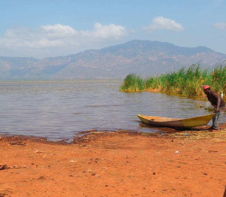
Image of Lake Jipe by River Lumi Resort
Covering approximately 30 square kilometers, Lake Jipe is fed primarily by the Lumi River and underground springs. It is ecologically significant, supporting a diverse range of flora and fauna, including hippos, crocodiles, and endemic fish species.
Lake Chala

Image of Lake Chala by Stephanie
Lake Chala is a stunning caldera lake straddling the Kenya–Tanzania border, just east of Mount Kilimanjaro and 8 km north of Taveta. Covering about 4.2 km² and plunging to roughly 95–98 meters deep, it's one of Africa’s deepest crater lakes.Lake chala shelters the critically endangered Lake Chala tilapia (Oreochromis hunteri), endemic and threatened by invasive tilapia species
Lake Kamnarok
Lake Kamnarok is a seasonal freshwater ox‑bow lake at the base of the Kerio Valley in Baringo/Elgeyo-Marakwet Counties, Kenya, formed in 1961 when the Kerio River changed course Covering about 1 km², it shrinks or even dries during Kenya’s dry season.

Image of Lake Kamnarok by Kenya Pics
The lake and surrounding 66 km² Kerio Valley National Reserve were gazetted in 1983, preserving semitropical slopes above thorn bush valley floor .It was once a crucial wildlife waterhole—supporting up to 500 elephants in the 1980s—and home to Africa’s second-largest crocodile population 10,000 at peak .However, human encroachment, agricultural expansion, overgrazing and climate shifts have reduced water levels, killed hundreds of crocodiles, and threaten the lake’s ecosystem
Lake Amboseli

Aerial View of Lake Amboseli by earth escape on IG
Lake Amboseli is a seasonal, shallow lake located within Amboseli National Park in southern Kenya, near the Tanzanian border and the base of Mount Kilimanjaro. The lake typically appears during the rainy season and dries up almost completely during dry months, leaving behind a flat, dusty salt pan.

Although it does not retain water year-round, Lake Amboseli plays a crucial ecological role. When filled, it attracts large flocks of flamingos, pelicans, and other waterbirds. The surrounding park is renowned for its elephant herds, wildlife diversity, and scenic views of Kilimanjaro.
Lake Ol Bolossat
Kenya’s Highest Altitude Lake

Lake Ol’ Bolossat, the only natural freshwater lake in central Kenya, spans about 43 km² at 2,340 m altitude, nestled between the Aberdare Range and Dundori Ridge . It forms the headwaters of the Ewaso Ng’iro River, crucial for communities and wildlife across five counties .

Image of lake Lake Olbolossat by eawildlife
The shallow basin (2 m deep) supports hippos, over 300 bird species—including breeding Grey Crowned Cranes, Red-knobbed Coots, and African Jacana—and vibrant montane grasslands . Human pressures—deforestation, agriculture, siltation, water abstraction—have shrunk surface area sharply from 10,000 ha to around 3,000 ha
Lake Kanyaboli

Image of a fisherman at Lake Kanyaboli by peter.achayo
Lake Kanyaboli is Kenya’s largest ox‑bow lake—and Africa’s second largest—nestled within Yala Swamp, Siaya County Covering about 1,500 ha with an average depth near 3 m, it receives floodwaters from Yala and Nzoia rivers and back-seepage from Lake Victoria Thick papyrus and sedges filter river water, improving clarity and supporting rare wildlife, including Sitatunga antelopes and papyrus-dependent birds
Lake Sonachi

Lake Sonachi, also known as Crater Lake, is a small, scenic alkaline lake located in Nakuru County, Kenya, within the Great Rift Valley. Formed in a volcanic crater, it lies near Lake Naivasha and is surrounded by lush forest and rich wildlife.

Despite its alkaline nature, Lake Sonachi supports flamingos and other bird species due to its high algae content. The lake is part of the Crater Lake Game Sanctuary, which hosts giraffes, zebras, and antelope.

Lake Oloiden is a small alkaline lake situated in Nakuru County, Kenya, adjacent to the southwestern edge of Lake Naivasha within the Great Rift Valley. Historically connected to Lake Naivasha, it now often stands as a separate water body due to fluctuating water levels and a papyrus swamp barrier.

Image of Lake Oloiden by Wangari wa Kuria
The lake's name, "Oloiden," means "salty" in the Maasai language, reflecting its saline and alkaline nature. Lake Oloiden is renowned for attracting flamingos, pelicans, cormorants, herons, and various waterfowl, thanks to its rich algae content . The surrounding grasslands are inhabited by buffaloes, hippos, giraffes, zebras, warthogs, and antelopes, making it a haven for nature enthusiasts. The lake's serene environment offers opportunities for birdwatching, boat rides, and camping
Endorheic means lakes that have no outlet, and water exits only through evaporation.
How Many Lakes are there In Kenya?
Kenya is home to approximately 64 lakes, with around 12 major ones being widely recognized for their ecological, economic, and cultural importance. Most are located in the Great Rift Valley, including Lake Turkana, Lake Nakuru, Lake Naivasha, Lake Baringo, and Lake Bogoria. Others, like Lake Victoria (shared with Uganda and Tanzania) and Lake Chala, are found outside the Rift Valley.
Kenya's top five largest lakes vary in size and ecological significance. Lake Turkana is the largest, covering approximately 6,405 km², and is both saline and alkaline. It lies in the arid north and supports unique wildlife. Lake Victoria, shared with Uganda and Tanzania, is the second largest in Kenya (Kenya’s portion is about 4,100 km²) and is the world’s second-largest freshwater lake. Lake Baringo is third, a freshwater lake covering around 130 km², supporting fisheries and birdlife. Lake Naivasha, also freshwater, spans about 139 km². Lake Magadi, a hypersaline lake, ranks fifth, covering around 100 km², known for soda ash deposits.
Kenya’s lakes vary in size, with the largest being Lake Turkana at approximately 6,405 km², a saline and alkaline desert lake in the north. Next is Lake Victoria, with Kenya’s portion covering about 4,100 km², shared with Uganda and Tanzania. Lake Baringo follows, a freshwater lake around 130 km², important for fisheries and birds. Lake Naivasha, also freshwater, spans about 139 km², supporting agriculture and tourism. Lake Magadi, a hypersaline lake in Kajiado, is roughly 100 km². Other notable smaller lakes include Lake Nakuru (45 km²), Lake Bogoria (34 km²)
Kenya is home to several saline (salty) lakes, primarily located in the Great Rift Valley. The four main salty water lakes are Lake Turkana, Lake Magadi, Lake Bogoria, and Lake Elementaita.
These include Lake Turkana, Lake Bogoria, Lake Elementaita, Lake Magadi, and Lake Nakuru.The lack of outlets in these lakes results in high mineral concentrations and unique ecosystems adapted to harsh,
Yes, Lake Naivasha is a freshwater lake located in Kenya's Rift Valley. Unlike most Rift Valley lakes, it has low salinity due to underground seepage and inflow from rivers like Malewa.
Lake Turkana is the deepest lake in Kenya, with a maximum depth of about 109 meters (358 feet). Located in the arid north, it is also the largest desert lake in the world. Its depth supports unique aquatic life, including Nile crocodiles
Lake Naivasha is famous for its freshwater, scenic beauty, and rich biodiversity, including hippos and over 400 bird species. It supports Kenya’s floriculture industry, with numerous flower farms along its shores. Popular for tourism, boat rides, and nearby attractions like Crescent Island
Lake Nakuru is better for wildlife viewing, especially flamingos, rhinos, and lions within Lake Nakuru National Park. Lake Naivasha is ideal for recreation, boat rides, and scenic relaxation. Both are unique—Nakuru offers a safari experience, while Naivasha provides diverse activities and is more accessible for casual tourism.

The main river that flows into Lake Naivasha is the Malewa River, which originates from the Aberdare Ranges. It provides most of the lake’s freshwater. Other contributors include the Gilgil and Karati Rivers.


Comments