Top 10 Hills in Kenya: Scenic Hikes, Views & Hidden Gems
- BeyondForest

- May 7, 2025
- 7 min read
Updated: Apr 14
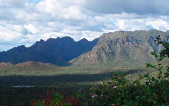
Image of Cherengani Hills By Treasures Of Kenya

Image of Cherengani Hills by Treasures of Kenya
Kenya is home to numerous hills and highlands, which are not only scenic but also play vital roles in climate regulation, cultural identity, and biodiversity conservation. These hills are scattered across various counties and range from volcanic cones to granite outcrops and forested uplands. Many serve as water catchment areas, while others are famous for hiking, spiritual rituals, or historical significance.
🚀 500+ Buyers Visit Beyond Forest Daily
Backed by 3.9M impressions and 44K+ clicks, Beyond Forest is already connecting demand to suppliers.
⚠️ Only 1 featured supplier slot per page
📲 Advertise your business today
Ngong Hills | Nairobi County |
Taita Hills | Taita-Taveta County |
Shimba Hills | Kwale County |
Kirira Hill | Meru County |
Ndoto Hills | Samburu County |
Chyulu Hills | Between Tsavo and Amboseli |
Kabirirsang Hills | Nandi County |
Cherengani Hills | Marakwet County |
Nyambene Hills | Meru County |
Huri Hills | Marsabit County |
Loita Hills | Narok County |
Loima Hills | Turkana County |
📍 Visit Beyond Forest Cyber Office Today (3 mins from Windsor)

Services:
📄 Bulk Printing, Photocopy & Scanning
🧾 KRA Returns, PIN & Tax Services
🚗 NTSA Services (DL, Smart DL, TIMS)
🏢 eCitizen Services (Certificates, Applications)
📑 CV Writing & Document Formatting
📊 Online Applications & Form Filling
📲 WhatsApp / Call: 0748102359 /0712582851
The Cherengani Hills
The Cherangani Hills are a prominent highland range located in western Kenya, spanning Trans Nzoia, West Pokot, and Elgeyo-Marakwet counties. Rising to altitudes of over 3,500 meters, the hills are part of Kenya’s key water catchment areas, feeding rivers like the Nzoia and Turkwel. They feature a mosaic of indigenous forests, grasslands, and montane ecosystems, making them a biodiversity hotspot.
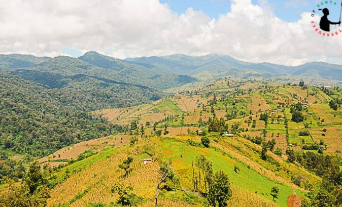
Image of Cherengani Hills which spans 3 counties Elgeyo Marakwet, Trans Nzoia and West Pokot by Treasures Of Kenya
The Huri Hills
The area has archaeological significance and offers sweeping views of the Chalbi Desert. Huri Hills remain largely untouched, making them ideal for adventure tourism and ecological research.
The Huri Hills are a remote and scenic highland region located in northern Kenya, within Marsabit County, near the Kenya–Ethiopia border. Rising above the surrounding arid plains, the Huri Hills reach elevations of about 1,500 to 1,700 meters and are characterized by gently sloping grasslands and scattered volcanic rock formations. Despite being in a generally dry area, the hills enjoy slightly cooler temperatures and support seasonal grazing for pastoralist communities like the Rendille and Gabra.

Image of Huri Hills By Gibbons Miller
The Huri Hills, a remote region of large lava cones, is located on the extreme North of Kenya between the Chalbi Desert and the Kenyan-Ethiopian border. It is the home of the Gabra and Borana people.
The Ngong Hills
The Ngong Hills are a series of scenic ridges located southwest of Nairobi, in Kajiado County, forming part of the Great Rift Valley escarpment.
Ngong Hills are popular for hiking, picnics, and photography, and are also home to a wind farm that supplies renewable energy.
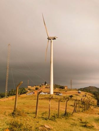
Rising to an altitude of about 2,460 meters, the hills offer panoramic views of Nairobi City to the east and the Great Rift Valley to the west. The name "Ngong" comes from the Maasai word enkong'u, meaning “knuckles,” referring to the hilltops’ resemblance to a clenched fist.

Image of Ngong Hills by Kenya Pics
Chyulu Hills
The Chyulu Hills serve as a critical water catchment for the Tsavo and Galana Rivers, supporting both wildlife and nearby communities.
The Chyulu Hills are a striking volcanic mountain range located between Tsavo West National Park and Amboseli National Park, stretching across Makueni and Kajiado counties in southeastern Kenya.

These hills are relatively young geologically, with some lava flows estimated to be just a few hundred years old. Rising to about 2,188 meters, they are covered with lush montane forests, grasslands, and caves, including the Leviathan Cave, one of the longest lava tubes in the world.
Loita Hills
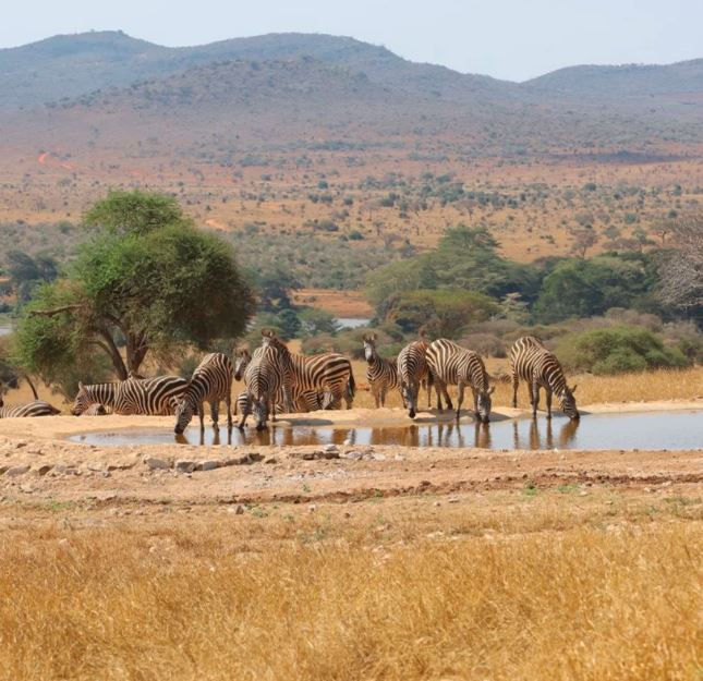
The Loita Hills are home to diverse flora and fauna, including elephants, leopards, and rare bird species.

The Loita Hills, also known as the Entim e Naimina Enkiyio (Forest of the Lost Child), are a remote and culturally rich highland range located in Narok County, southern Kenya, near the Tanzania border. Rising to elevations of about 2,300 meters, the hills are blanketed in indigenous forests and serve as an important water catchment area. They are sacred to the Loita Maasai, who have preserved the forest through traditional stewardship.
Loima Hills
The Loima Hills are a rugged highland range located in western Turkana County, northwestern Kenya, forming part of the western edge of the Great Rift Valley. Rising to elevations of around 2,200 meters, the hills stretch from near Lodwar toward the Ugandan border.

Loima Hills are vital to the Turkana pastoralist communities, serving as key dry-season grazing areas due to their slightly cooler climate and scattered vegetation.
Loima Hills also locally referred to as ‘Murua Ngithigerr', which together combined with the Puch Prasir plateau represent one of the most extensive highland areas in Turkana County.
Taita Hills
The Taita Hills are a scenic and ecologically rich mountain range located in Taita-Taveta County, southeastern Kenya, near Tsavo West National Park. Rising to elevations of over 2,200 meters,
The Taita hills are part of the Eastern Arc Mountains, one of the world’s oldest mountain ranges. They are divided into Dawida, Sagalla, and Kasigau hill blocks. The Taita Hills are a biodiversity hotspot, home to rare and endemic species like the Taita thrush and Taita apalis.
The Nandi Hills

Image of Nandi Hills
Nandi Hills, located in Nandi County in western Kenya, are a highland area rising to about 2,000 meters above sea level. Known for their cool climate and lush landscapes, the hills are famed for tea plantations and fertile soils that support large-scale agriculture. The area holds great cultural significance to the Nandi people, including being the home of the legendary leader Koitalel Arap Samoei. Nandi Hills also serve as a key water catchment, feeding rivers like the Yala and Nzoia. The region is a training ground for world-class athletes and attracts visitors for its scenic views, heritage sites, and cool weather.
Nyambene Hills
The Nyambene Hills are a lush volcanic mountain range located in Meru County, on the northeastern slopes of Mount Kenya. Rising to elevations of around 2,500 meters, the hills are covered with indigenous forests, farmlands, and tea plantations.

Image of Nyambene Hills by Hiking Wolf
They form part of the Nyambene Forest Reserve, a critical water catchment feeding rivers like Isiolo and Tigania. The area is known for its fertile volcanic soils, ideal for growing miraa (khat), bananas, and cereals. The hills are culturally significant to the Meru people, featuring sacred sites and traditional shrines.
Kakamega Hills
The Kakamega Hills are part of the Kakamega Forest ecosystem, located in Kakamega County in western Kenya. These low-lying, mist-covered hills are nestled within Kenya’s only tropical rainforest, the Kakamega Forest, a remnant of the ancient Guineo-Congolian forest. The hills rise to elevations of around 1,700 meters, with Buyangu Hill and Lirhanda Hill being notable peaks. Rich in biodiversity, the area hosts over 300 bird species, unique primates like the black-and-white colobus monkey, and rare plants.
Lolgorian Hills
The Lolgorian Hills are located in Narok County, southwestern Kenya, near the border with Tanzania and close to the Trans Mara region. These rolling hills lie west of the Maasai Mara National Reserve and form part of the Mara ecosystem. Rising to moderate elevations, the Lolgorian Hills are covered with a mix of grasslands, shrubs, and patches of forest, making them ideal for grazing and supporting diverse wildlife.
Ng’iro Hills
The Ng’iro Hills are a remote and rugged mountain range located in northern Kenya, specifically in Samburu County, near the edge of the Suguta Valley. Rising to elevations of about 2,800 meters, these hills are sacred to the Samburu people, who consider them a spiritual place and a refuge for both people and livestock during droughts.
What are the names of the hills in Kenya?
Kenya is home to many notable hills spread across the country, each with unique ecological and cultural significance. Some well-known hills include Ngong Hills (Kajiado) ,Taita Hills (Taita-Taveta) ,Chyulu Hills (Makueni/Kajiado) ,Loita Hills (Narok) ,Loima Hills (Turkana), Cherangani Hills (Trans Nzoia/West Pokot), Nandi Hills (Nandi), Shimba Hills (Kwale), Nyambene Hills (Meru) and Kakamega Hills (Kakamega)

Image of Kiborgok Hill Nandi County
How many Hills are In Kenya
Kenya has hundreds of hills, both named and unnamed, scattered across its diverse landscapes from highland regions to arid zones. While there is no exact official count, notable hill ranges include the Ngong Hills, Taita Hills, Chyulu Hills, Loita Hills, Nandi Hills, Cherangani Hills, Nyambene Hills, Loima Hills, and Shimba Hills, among many others.

Image of Lenkiyio Hills, also known as Matthews Ranges, in Samburu
Which is the highest Hill In Kenya
The Cherangani Hills are considered the highest hill range in Kenya, with peaks reaching up to 3,365 meters (11,040 feet) above sea level. Located in western Kenya, spanning Trans Nzoia, Elgeyo-Marakwet, and West Pokot counties
The Cherangani Hills are part of Kenya’s major water catchment areas.

Image of Chatambe Hills that stretches from Webuye and Kakamega by ItsJeffreyJeff
What are examples of hills in Nairobi County?
Examples of hills in Nairobi County include Ngong Hills Loresho Hill Kilimani Hill Gigiri Ridge and City Park Hill

Aerial View of Loita Hills
What is the meaning of Ngong Hills?
The name Ngong Hills comes from the Maasai word “enkong’u emuny”, which means “knuckles of the bull” or simply “knuckles”. This refers to the hill range’s distinct shape—four rounded peaks that resemble the knuckles of a clenched fist.
Where are Ngong Hills?
Ngong Hills are located in Kajiado County, along the southern edge of Nairobi, approximately 25 kilometers southwest of Nairobi’s city center.


Comments