Mount Kenya Climbing Routes Map Explained: Sirimon, Chogoria & Naro Moru Routes to Point Lenana and Batian
- BeyondForest

- Mar 12
- 6 min read

Image of a Rhino and calf in grassy plain against mount Kenya backdrop. Rhino Kennedy
1.)Introduction to Mount Kenya Climbing
3.)Main Peaks of Mount Kenya
4.)Sirimon Route (Most Popular Climbing Route)
5.)Chogoria Route (Most Scenic Route)
8.)Lewis Glacier and Diamond Couloir
9.)How Long It Takes to Climb Mount Kenya
11.)Mount Kenya Expedition Costs
12.)Best Time to Climb Mount Kenya

Standing at 5,199 meters, Mount Kenya is the second highest mountain in Africa after Mount Kilimanjaro. The mountain features dramatic peaks, alpine valleys, glaciers, and diverse hiking routes that attract trekkers and climbers from around the world. Popular trekking routes lead hikers to Point Lenana, while experienced mountaineers attempt the technical peaks of Batian and Nelion. The climb offers breathtaking scenery, unique high-altitude vegetation, and unforgettable sunrise views above the clouds.
Mount Kenya Routes Map Explained

A Mount Kenya routes map helps climbers understand the mountain’s complex terrain and plan their ascent safely. The map shows key features such as major peaks, glaciers, valleys, climbing routes and high-altitude camps. Important locations include Teleki Valley, Mackinder Camp, American Camp, Lewis Glacier and the Diamond Couloir climbing route. By studying the map, hikers can visualize how different trekking routes connect and estimate travel times between camps.
Main Peaks of Mount Kenya
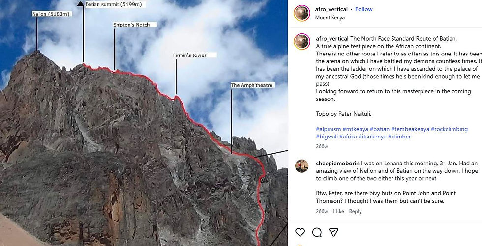
Mount Kenya has three main peaks that attract climbers and trekkers from around the world. The highest peak is Batian at 5,199 meters, followed by Nelion at 5,188 meters. These two peaks require technical rock climbing skills and are mainly attempted by experienced mountaineers. The third peak, Point Lenana at 4,985 meters, is the most popular summit because it can be reached through trekking routes without technical climbing equipment.
Sirimon Route (Most Popular Climbing Route)

Image of Mak Mansa on the Top of Mount Kenya
The Sirimon Route is one of the most popular ways to climb Mount Kenya because it offers a gradual ascent and excellent acclimatization for hikers. The trail begins on the northern side of the mountain and passes through forests, moorlands, and alpine valleys before reaching high-altitude camps such as Shipton’s Camp. Many climbers use this route to reach Point Lenana, the trekking summit.
Chogoria Route (Most Scenic Route)
The Chogoria Route is widely considered the most scenic route on Mount Kenya. The trail approaches the mountain from the eastern side and passes through breathtaking landscapes including waterfalls, alpine valleys, and the stunning Lake Michaelson. Climbers also enjoy spectacular views of the peaks Batian, Nelion, and Point Lenana, making this route a favorite for photographers and adventure trekkers.
Naro Moru Route (Fastest Route to the Summit)
The Naro Moru Route is the fastest and most direct way to climb Mount Kenya, making it popular among hikers with limited time. The route approaches the mountain from the western side and features a steep ascent, including the famous Vertical Bog section. Many climbers use this trail to reach Point Lenana, the trekking summit of Mount Kenya.
Teleki Valley and Mackinder Camp
Teleki Valley is one of the most beautiful alpine valleys on Mount Kenya and serves as a key route toward the summit area. Located below the towering peaks of Batian and Nelion, the valley features dramatic landscapes and unique high-altitude vegetation such as giant lobelias. Mackinder Camp, situated within the valley, is a major overnight stop for climbers preparing for the final ascent to Point Lenana.
Lewis Glacier and Diamond Couloir
Want To Learn More About The Yellow Fever Tree Learn Here >>>

Lewis Glacier is the largest remaining glacier on Mount Kenya and lies beneath the steep peaks of Batian and Nelion. It forms part of the dramatic alpine environment near the summit area. Nearby is the famous Diamond Couloir, a steep ice and snow gully that provides a challenging technical climbing route used by experienced mountaineers attempting the highest peaks of the mountain.
Route | Typical Duration | Difficulty Level | Notes |
Sirimon Route | 4 – 5 Days | Moderate | Best for gradual acclimatization |
Chogoria Route | 4 – 6 Days | Moderate | Most scenic route with lakes and valleys |
Naro Moru Route | 3 – 4 Days | Moderate to Difficult | Fastest but steepest route |
Sirimon – Chogoria Traverse | 5 – 6 Days | Moderate | Popular for full Mount Kenya experience |
Technical Climb (Batian / Nelion) | 4 – 7 Days | Difficult | Requires rock climbing skills |
Mount Kenya vs Kilimanjaro
Mount Kenya and Mount Kilimanjaro are the two highest mountains in Africa, but they offer different climbing experiences. Mount Kilimanjaro is higher at 5,895 meters and is mainly a trekking mountain without technical climbing routes. Mount Kenya, at 5,199 meters, has dramatic rocky peaks such as Batian and Nelion, which require technical climbing skills. However, hikers can still reach Point Lenana, the trekking summit, making Mount Kenya a versatile destination for both trekkers and experienced climbers.
Mount Kenya Expedition Costs
Cost Item | Typical Cost | What It Covers |
Park Entry Fees | ~KSh 800 per day (citizens) / ~$60–70 per day (foreigners) | Access to Mount Kenya National Park |
Guide | $20–40 per day | Professional mountain guide to lead the trek |
Porter | $10–20 per day | Carries tents, food, and heavy luggage |
Meals | $10–25 per day | Breakfast, lunch, and dinner prepared on the mountain |
Accommodation | $20–50 per night | Camping tents or mountain huts like Mackinder Camp |
Transport to Mountain | $50–150 | Travel from Nairobi or Nanyuki to the park gate |
The best time to climb Mount Kenya is during the dry seasons, when the weather is more stable and visibility is clear. The most favorable months are January to March and July to October. During these periods, climbers experience less rain, safer trails, and better summit views.
Frequently Asked Questions About Mount Kenya Climbing Routes
1. How long does it take to climb Mount Kenya?
Climbing Mount Kenya usually takes 3 to 5 days depending on the route used and the climber’s fitness level. The Naro Moru route is the fastest and can take about 3–4 days, while the Sirimon and Chogoria routes typically take 4–5 days. Climbers attempting the technical peaks Batian or Nelion may require additional days for preparation and ascent.
2. What is the best route to climb Mount Kenya?
The Sirimon route is considered the best route for many climbers because it has a gradual ascent and good acclimatization. The Chogoria route is the most scenic, offering views of waterfalls, lakes and valleys. The Naro Moru route is the fastest but also the steepest and more physically demanding.
Yes, beginners can climb Mount Kenya if they aim for Point Lenana (4,985 m), which is the trekking summit. This peak does not require technical climbing skills and can be reached with a guide. However, climbing Batian or Nelion, the highest peaks, requires technical rock climbing experience.
4. What is the Mount Kenya routes map used for?
A Mount Kenya routes map helps climbers understand the main hiking trails, valleys, glaciers and camps on the mountain. It shows key locations such as Teleki Valley, Mackinder Camp, Lewis Glacier, American Camp and Diamond Couloir, helping climbers plan their ascent safely.
5. What is the height of Mount Kenya?
Mount Kenya is 5,199 meters (17,057 ft) above sea level, making it the second highest mountain in Africa after Mount Kilimanjaro in Tanzania.
6. What are the main peaks of Mount Kenya?
Mount Kenya has three major peaks:
Peak | Height | Difficulty |
Batian | 5,199 m | Technical climbing |
Nelion | 5,188 m | Technical climbing |
Point Lenana | 4,985 m | Trekking summit |
7. Is Mount Kenya harder to climb than Kilimanjaro?
Mount Kenya can be more challenging for climbers attempting Batian or Nelion, because these peaks require technical rock climbing skills. However, reaching Point Lenana is generally considered easier than climbing Mount Kilimanjaro.
The best time to climb Mount Kenya is during the dry seasons, which occur from January to March and July to October. During these months the weather is more stable and the trails are safer for trekking.
9. Do you need a guide to climb Mount Kenya?
Yes. All climbers entering Mount Kenya National Park are required to register and it is highly recommended to hire a certified guide or tour operator for safety and navigation.
10. What wildlife can you see while climbing Mount Kenya?
While hiking on Mount Kenya, visitors may see wildlife such as:
Rock hyrax
Mountain antelope
Colobus monkeys
Giant lobelia plants
Alpine vegetation unique to high altitudes.


Comments